Wednesday 19 April 2017
Old Gaffer sails classic yacht Winifred
|
Notices to Mariners Week 17 - Notices to Mariners for the Southern East Coast of the UK and across to France, Belgium and part of Holland

Permanent
1. ENGLAND - East Coast - Lowestoft - NM Block. Light. - change of light characteristics of the Kirkley shore light (south of Lowestoft) - there is a UKHO chart block that can be downloaded in addition to my image see: http://www.crossingthethamesestuary.com/page9.html
2. ENGLAND - East Coast - Sizewell Bank - Buoyage. Lights. - change of lights and their characteristics;
3. ENGLAND - East Coast - Orford Ness NE - Depths. - two reduced depths on the Aldeburgh Ridge - worth noting for those who pass;
4. ENGLAND - East Coast - Sizewell Bank to Aldeburgh Ridge - Wrecks. Depths. - six new wrecks but all of them at 8.9m or more.
Temporary
1. Trinity House has notified to moves to the Barrow No 8 and No 10. Both moves are very minimal;
2. Orwell Bridge Inspection works - 15th May to mid-May. Day and Night with a Safety Boat at all times;
3. Event at Pin Mill on 13th May involving the Nancy Blackett and 'other small vessels' between 1200 to 1700.
Read more at http://www.ybw.com/forums/showthread.php?477078-Notice-to-Mariners-Week-17#C7zVDATehT56MzLf.99
Local NtMs compiled by and reproduced by kind permission of Roger Gaspar, author of Crossing the Thames Estuary
Thursday 13 April 2017
Notices to Mariners Week 16 - Notices to Mariners for the Southern East Coast of the UK and across to France, Belgium and part of Holland

Quite a lot this week, including some disturbing developments at Whitstable for anyone venturing inshore. See additional link below:
Permanent - five UKHO and one Trinity House:
1. ENGLAND - East Coast - Walton Backwaters - NM Block. Depths. - Revised depths at Island Point and Stone Point on the Walton Backwaters. The UKHO has issued a block for the Admiralty Chart which is downloadable on http://www.crossingthethamesestuary.com/page9.html: The block is UKHO copyright;
2. ENGLAND - Thames Estuary - Mouse Channel SE - Buoyage. Changes of yellow special marks to the south-east of the No 14 Barrow Deep port hand buoy and closer to the Alice danger buoy. See image usual page;
3. ENGLAND - East Coast - River Thames - Halfway Reach - Depths. reduced depth off Dagenham Ford works. Un likely to hinder leisure craft;
4. ENGLAND - East Coast - Lower Road (approaches to Boston) - Drying heights on the south/eastern edge of the Lower Road channel;
5. ENGLAND - East Coast - Whitstable Bay - Marine farm. Legends. - large area twix the Swale and Whitstable Harbour designated as a marine farm (for Oysters - numerous obstructions!);
6. The Trinity House NtM issued tonight - re-position of the Oxley and Weir buoys at the entrance to the Ore - image on the same page above.
Temporary
1. River Thames - Erith Reach - the Causeway is now open for use;
2. Harwich - Ha'penny Pier - details of this year's usage and a useful download of the leisure uses of the Stour and Orwell. On the Temporary list in the usual web page;
3. Harwich - Dredging from 20th April for about 6 days - Work between the Port of Ipswich and the River Orwell, debris to be 'dumped in the Long Reach;
4. Lowestoft - Lake Lothing - the Compass Buoy has been permanently removed;
5. Lowestoft - Dredging most of April and early May - three vessels to be used but area not specified;
6. Port of Wells - dredging;
7. Port of Ramsgate - Temporary race marks reinstated.
More info on Whitstable Marine Farm http://www.kentonline.co.uk/whitstable/news/oyster-racks-ordered-to-be-122208/
Local NtMs compiled by and reproduced by kind permission of Roger Gaspar, author of Crossing the Thames Estuary
Tuesday 11 April 2017
Another busy day lifting Boats back in the water

Pictures from Tuesday with 3 of the biggest heaviest boats moved.


Friday 7 April 2017
River Medway Nursery Area: No-Take Zone
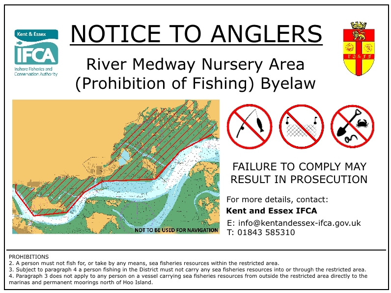
River Medway Nursery Area: No-Take Zone
Working with Rochester Oyster and Floating Fishery, Kent and Essex Inshore Fisheries and Conservation Authority (IFCA) is leading the way in marine conservation with the creation of the UK's largest no-take zone in the Medway Estuary. The no-take zone covers 12.1 square kilometres (4.6 square miles) of saltmarsh and mudflat environments that are vitally important to a wide variety of …
Wednesday 5 April 2017
Notices to Mariners Week 15 - Notices to Mariners for the Southern East Coast of the UK and across to France, Belgium and part of Holland

Permanent UKHO Notices
Three this week:
1. A number of southern North Sea charts are being updated as a result of the Dutch changes to the North Hinder TSS etc. These are being published on 13th or 27th April and affect:
Chart 110 - International Chart Series, North Sea - Netherlands, Westkapelle to Stellendam and Maasvlakte. 1:75,000: A Noordland Roompotsluis. 1:40,000: B Slijkat to Stellendam. 1:50,000
Chart 1630 - International Chart Series, North Sea, Netherlands, West Hinder and Outer Gabbard to Vlissingen and Scheveningen. 1:150,000
Chart 1406 - North Sea, Dover and Calais to Orford Ness and Scheveningen 1:250,000
Chart 1408 - North Sea, Harwich and Rotterdam to Cromer and Terschelling 1:300,000
Chart 1872 - North Sea, Dunkerque to Vlissingen. 1:100,000: A Nieuwpoort. 1:20,000: C Oostende. 1:15,000: B Zeebrugge. 1:20,000: C Blankenberge. 1:15,000
Chart 1873 - North Sea, Dunkerque to Oostende. 1:60,000: A Oostende. 1:15,000: B Niewpoort 1:20,000
Chart 1874 - International Chart Series, North Sea, Westerschelde Oostende to Westkapelle. : A Vlissingen 1:25,000: B Zeebrugge 1:20,000: C Brugge 1:15,000
Chart 2449 - North Sea, Dover Strait to Westerschelde. 1:150,000
2. ENGLAND - Thames Estuary - Fisherman’s Gat - Depths. - a reduced of depth just south of the re-positioned Inner Fisherman (port hand buoy) but it's 7.4m so unlikely to hinder us;
3. FRANCE - North Coast - Ridens de Calais - Automatic Identification System. The RCA north cardinal off Calais is now 'on' AIS.
Temporary
Nice week - just the one notice:
Port of Wells - still digging.
Local NtMs compiled by and reproduced by kind permission of Roger Gaspar, author of Crossing the Thames Estuary
Subscribe to:
Posts (Atom)